
File:Eq-prob.jpg
Dimensioni di questa anteprima: 448 × 600 pixel. Altre risoluzioni: 179 × 240 pixel | 535 × 716 pixel.
File originale (535 × 716 pixel, dimensione del file: 150 KB, tipo MIME: image/jpeg)
Se non hai mai usato Commons, visita la pagina di benvenuto, o leggi le FAQ.
Visualizza quali progetti usano questa immagine.
Dettagli
| Descrizione |
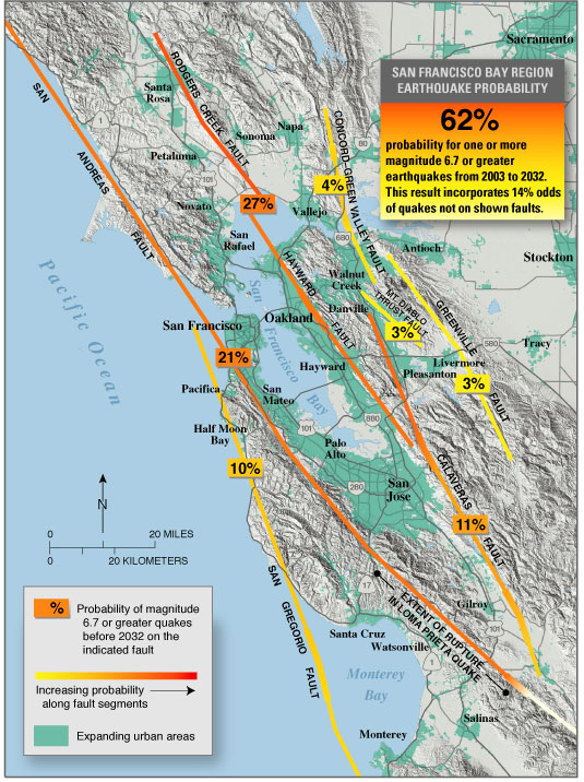
English: USGS seismic hazard map showing the probability of an M6.7 or greater earthquake occurring in the San Francisco Bay Area between 2003 and 2032.
Recent (January 2008) assessments (San Jose Mercury News: Hayward fault might be more dangerous than scientists thought ) suggest that the Hayward, Rodgers Creek, and northern Calaveras faults may be more likely to fail in the next few decades than previously thought (more so than is indicated on this map). |
| Fonte | https://pubs.usgs.gov/fs/old.2003/fs039-03/ |
| Autore |
Licenza
Quest'immagine è nel pubblico dominio perché contiene materiale proveniente dallo United States Geological Survey, un'agenzia del Dipartimento degli Interni degli Stati Uniti. Per maggiori informazioni vedere la politica ufficiale dell'USGS sul copyright.
|
Registro originale del caricamento
La pagina di descrizione originale era qui. Tutti i nomi utente che seguono sono riferiti a en.wikipedia.
- 2005-05-04 07:16 RockBandit 535×716×8 (153090 bytes) [[USGS]] seismic hazard map showing the probability of a M6.7 or greater earthquake occuring in the [[San Francisco Bay Area]] between [[2003]] and [[2032]]. {{PD-USGov-Interior-USGS}}
Cronologia del file
Fare clic su un gruppo data/ora per vedere il file come si presentava nel momento indicato.
| Data/Ora | Miniatura | Dimensioni | Utente | Commento | |
|---|---|---|---|---|---|
| attuale | 22:21, 13 mag 2008 | | 535 × 716 (150 KB) | Satipatthana | {{Information |Description={{en|en:USGS seismic hazard map showing the probability of an M6.7 or greater earthquake occurring in the en:San Francisco Bay Area between en:2003 and en:2032. Recent (January 2008) assessments (San Jose Me |
Utilizzo del file
La seguente pagina usa questo file:
Utilizzo globale del file
Anche i seguenti wiki usano questo file:
- Usato nelle seguenti pagine di ar.wikipedia.org:
- Usato nelle seguenti pagine di de.wikipedia.org:
- Usato nelle seguenti pagine di en.wikipedia.org:
- Usato nelle seguenti pagine di en.wikibooks.org:
- Usato nelle seguenti pagine di es.wikipedia.org:
- Usato nelle seguenti pagine di gl.wikipedia.org:
- Usato nelle seguenti pagine di id.wikipedia.org:
- Usato nelle seguenti pagine di it.wikibooks.org:
- Usato nelle seguenti pagine di la.wikipedia.org:
- Usato nelle seguenti pagine di www.wikidata.org:
- Usato nelle seguenti pagine di zh.wikipedia.org: