
File:Iceberg A22A, South Atlantic Ocean.jpg

Dimensioni di questa anteprima: 800 × 530 pixel. Altre risoluzioni: 320 × 212 pixel | 640 × 424 pixel | 1 024 × 678 pixel | 1 280 × 848 pixel | 2 345 × 1 553 pixel.
File originale (2 345 × 1 553 pixel, dimensione del file: 793 KB, tipo MIME: image/jpeg)
Se non hai mai usato Commons, visita la pagina di benvenuto, o leggi le FAQ.
Visualizza quali progetti usano questa immagine.
Dettagli
| Descrizione |
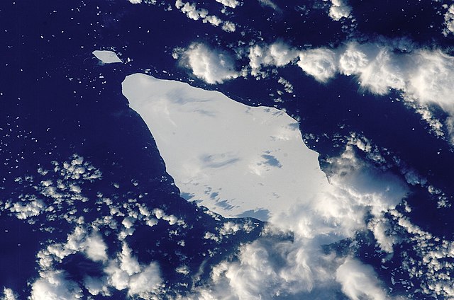
English: This astronaut photograph illustrates the remains of a giant iceberg—designated A22A— that broke off Antarctica in 2002. The iceberg was photographed at a location of 49.9 degrees south latitude, 23.8 degrees west longitude, which is about a third of the distance from South America towards Cape Town, South Africa. A22A is one of the largest icebergs to drift as far north as 50 degrees south latitude, bringing it beneath the daylight path of the International Space Station (ISS). Crew members aboard the ISS were able to locate the ice mass and photograph it, despite the great masses of clouds that often accompany winter storms in the Southern Ocean. The crew’s viewing angle was oblique (not looking straight down) from a point to the west of the berg, and the time of day was early afternoon, as shown by the orientation of the cloud shadows. Dimensions of A22A in early June were 49.9 by 23.4 kilometres, giving it an area of 622 square kilometres, or seven times the area of Manhattan Island.
|
||||||||||||||||||||||||||||||||||||||||||||||||||
| Data | |||||||||||||||||||||||||||||||||||||||||||||||||||
| Fonte | {{URL|example.com|optional display text}} | ||||||||||||||||||||||||||||||||||||||||||||||||||
| Autore | Image provided by the ISS Crew Earth Observations experiment and the Image Science & Analysis Laboratory, NASA - Johnson Space Center. | ||||||||||||||||||||||||||||||||||||||||||||||||||
| Posizione del soggetto | | Posizione di questa e altre immagini su: OpenStreetMap |
|---|
Questa immagine o filmato è stato catalogato dal Johnson Space Center della National Aeronautics and Space Administration (NASA) degli Stati Uniti d'Americacon il Photo ID: ISS015-E-10125.Questo tag non indica lo status del copyright dell'opera ad esso associato. È quindi richiesto un normale tag di copyright. Vedi Commons:Licenze per maggiori informazioni. Altre lingue:
|
Licenza
| Questo file è nel pubblico dominio perché creato dalla NASA. La politica sul copyright della NASA afferma che «il materiale della NASA non è protetto da copyright a meno che non sia specificato altrimenti». (NASA copyright policy e JPL Image Use Policy). | ||
 |
Attenzione:
|
Cronologia del file
Fare clic su un gruppo data/ora per vedere il file come si presentava nel momento indicato.
| Data/Ora | Miniatura | Dimensioni | Utente | Commento | |
|---|---|---|---|---|---|
| attuale | 17:25, 22 mar 2013 | | 2 345 × 1 553 (793 KB) | Julian Herzog | Higher resolution and quality |
| 21:54, 5 lug 2009 |  | 1 000 × 1 000 (376 KB) | Originalwana | {{Information |Description={{en|1=This astronaut photograph illustrates the remains of a giant iceberg—designated A22A— that broke off Antarctica in 2002. The iceberg was photographed at a location of 49.9 degrees south latitude, 23.8 degrees west lon |
Utilizzo del file
La seguente pagina usa questo file:
Utilizzo globale del file
Anche i seguenti wiki usano questo file:
- Usato nelle seguenti pagine di ar.wikipedia.org:
- Usato nelle seguenti pagine di az.wikipedia.org:
- Usato nelle seguenti pagine di bn.wikipedia.org:
- Usato nelle seguenti pagine di cy.wikipedia.org:
- Usato nelle seguenti pagine di en.wikipedia.org:
- Usato nelle seguenti pagine di eo.wikipedia.org:
- Usato nelle seguenti pagine di it.wikipedia.org:
- Usato nelle seguenti pagine di it.wikibooks.org:
- Usato nelle seguenti pagine di la.wikipedia.org:
- Usato nelle seguenti pagine di mk.wikipedia.org:
- Usato nelle seguenti pagine di pt.wikipedia.org:
- Usato nelle seguenti pagine di sl.wikipedia.org:
- Usato nelle seguenti pagine di ta.wikipedia.org:
- Usato nelle seguenti pagine di ta.wiktionary.org:
- Usato nelle seguenti pagine di th.wikipedia.org: